近日,中国地质大学(武汉)国家地理信息系统工程技术研究中心张翔教授团队在数据智能融合领域取得了新进展,研究形成了城市群区域“三高”降水数据,并分析了地理时空因子在融合模型中的增益效果,研究成果发表在《Journal of Hydrology》和《Remote Sensing Applications: Society and Environment》等国际SCI期刊,体现出团队在这一前沿领域的持续性创新。
首先,基于前期提出的GRASPS(Generate high Resolution, Accurate, Seamless data using Point-Surface fusion)“三高”数据智能融合方法,对多源卫星降水数据及其他降水相关变量进行了融合校正,成功获得了高精度、高分辨率且高时空连续的武汉“1+8”城市圈融合降水数据集。研究结果显示,生成的降水数据集与地面雨量计测量真实降水之间的皮尔逊相关系数(PCC)达到了0.77。在强弱两种极端降水情况下,相比多种原始卫星降水数据,PCC提高了76.92%至91.76%。在空间分布的对比中,该研究生成的融合数据集表现出与地面站点最高的相似度。并且,通过重点分析Month和Day两种变量,证明了它们在降水融合建模中的重要性。论文题为“Data Fusion of Satellite Imagery and Downscaling for Generating Highly Fine-Scale Precipitation”,主要作者为张翔教授、宋宇硕士生、顾西辉教授、陈能成教授、中国科学院空天信息创新研究院曾江源副研究员、韩国韩京国立大学大学Won-Ho Nam副教授、德州大学奥斯汀分校Dev Niyogi教授等。
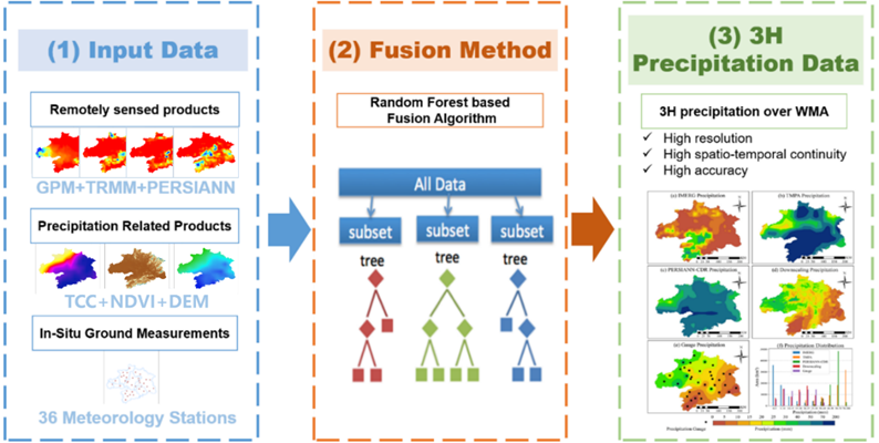
图1 基于GRASPS模型的多源降水数据融合降尺度方法
然后,为了分析地理时空因素在GRASPS “三高”数据智能融合方法的增益效果,研究了地理时空因素对温度融合数据输入、基于深度学习的融合模型和融合后温度误差标定等三个方面的影响。结果表明,在将地理空间自相关因子纳入融合模型后,与不考虑时空因素的模型相比,RMSE和MAE分别降低了68%和73%。通过地理时空差异分析(GSTDA)误差校正,结合时空因素补偿特定时间或地点的温度后,RMSE和MAE从0.75 °C降至0.64 °C–0.69 °C和0.58 °C,RMAE和MAE分别降低了9.37%和10.15%。论文题为“Considering geographical spatiotemporal attributes for seamless air temperature data fusion with high accuracy”,主要作者为张翔教授、黄泰来硕士生、顾西辉教授、陈能成教授、中国科学院空天信息创新研究院曾江源副研究员、埃塞俄比亚亚的斯亚贝巴大学Berhanu Keno Terfa助理教授、韩国韩京国立大学大学Won-Ho Nam副教授、德州大学奥斯汀分校Dev Niyogi教授等。
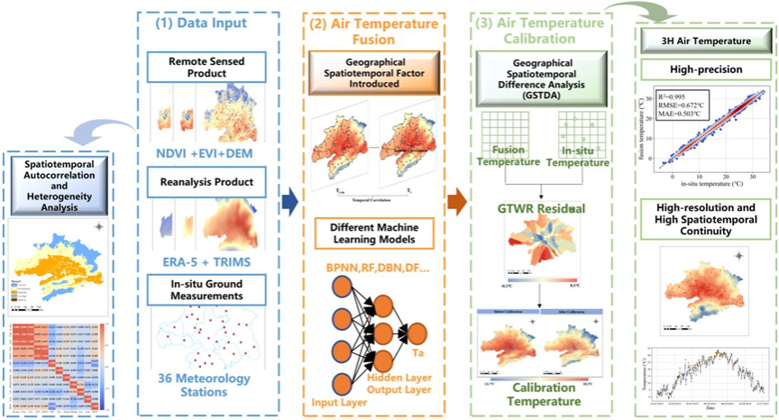
图2 考虑地理时空因素的多源气温数据融合降尺度方法
数据融合相关论文成果:
[1]. Zhang X*, Song Y., et al., Data Fusion of Satellite Imagery and Downscaling for Generating Highly Fine-Scale Precipitation, Journal of Hydrology, in Proof, 2024, 130665
[2]. Huang T, X Zhang X*, B. K. Terfa, et al., The influence of geographical spatio-temporal factors on seamless air temperature data fusion with high accuracy. Remote Sensing Applications: Society and Environment, Remote Sensing Applications: Society and Environment, 2023: 101135.
[3]. Zhang X.; Chen N.C.* Reconstruction of GF-1 Soil Moisture Observation based on Satellite and In Situ Sensor Collaboration under Full Cloud Contamination. IEEE Transactions on Geoscience and Remote Sensing. 2016, 54(9): 5185-5202.
[4]. Huang S.Z., Zhang X.*, Chen N.C. et al., A Novel Fusion Method for Generating Surface Soil Moisture Data with High Accuracy, High Spatial Resolution, and High Spatio-Temporal Continuity. Water Resources Research. 2022, 58(5): e2021WR030827.
[5]. Huang S.Z., Zhang X.*, Chen N.C. et al., Generating high-accuracy and cloud-free surface soil moisture at 1 km resolution by point-surface data fusion over the Southwestern U.S. Agricultural and Forest Meteorology, 2022, 321: 108985.
[6]. Xu L.; Chen N.C.; Moradkhani H.; Zhang X.*; Hu C.L.* Improving Global Monthly and Daily Precipitation Estimation by Fusing Gauge Observations, Remote Sensing, and Reanalysis Datasets. Water Resources Research. 2020, 56(3): e2019WR026444.
[7]. Zhang X*, Huang T, Gulakhmadov A, et al., Deep Learning-Based 500 m Spatio-Temporally Continuous Air Temperature Generation by Fusing Multi-Source Data. Remote Sensing. 2022; 14(15):3536.
[8]. Huang, S., Zhang, X., Wang, C., Chen, N.*, Two-step fusion method for generating 1 km seamless multi-layer soil moisture with high accuracy in the Qinghai-Tibet plateau. ISPRS Journal of Photogrammetry and Remote Sensing, 2023, 197: 346-363.

 扫码关注中心官微